Contents
Overview
The roots of geophysics stretch back to antiquity, with early observations of Earth's magnetic field and seismic activity laying foundational groundwork. The invention of the magnetic compass in ancient China, around the 2nd century BCE, marked an early understanding of Earth's magnetic properties. Later, in the 17th century, scientists like Edmond Halley began systematically studying Earth's magnetic variations, proposing that the field originated from within the planet. The development of seismometers in the 19th century, notably by Ernest Braun and John Milne, allowed for the recording of seismic waves, ushering in the era of modern seismology. By the early 20th century, pioneers like Beno Gutenberg and Inge Lehmann used seismic data to infer the existence of Earth's core and mantle, solidifying geophysics as a distinct scientific discipline.
⚙️ How It Works
Geophysics operates by applying physical laws and quantitative methods to observe and model Earth's systems. Techniques include seismic surveys, which use artificial or natural earthquakes to map subsurface structures by analyzing the travel times and amplitudes of seismic waves through different rock layers. Gravimetry measures minute variations in Earth's gravitational field, revealing density differences in the crust and mantle, crucial for understanding geological structures and mineral deposits. Magnetometry detects variations in Earth's magnetic field, aiding in the mapping of geological formations and the exploration for magnetic minerals like iron ore. Electrical and electromagnetic methods, such as magnetotellurics, probe the electrical conductivity of the subsurface, providing insights into fluid content and temperature. Remote sensing, using satellites and aircraft, gathers data on surface topography, temperature, and atmospheric composition, contributing to a comprehensive planetary view.
📊 Key Facts & Numbers
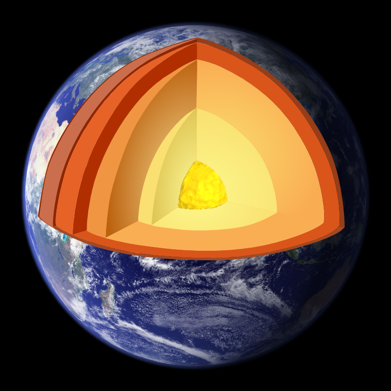
Earth's radius is approximately 6,371 kilometers (3,959 miles), and its mass is about 5.972 × 10^24 kilograms. The planet's magnetic field, generated by the motion of molten iron in the outer core, extends tens of thousands of kilometers into space, forming the magnetosphere, which shields us from harmful solar wind. Seismic waves from a magnitude 7.0 earthquake can travel around the entire globe. The gravitational anomaly in the Indian Ocean, known as the 'negative gravity anomaly,' is about 100 million square kilometers in area and represents a deficit of 0.3% in gravitational pull. The Earth's mantle convection currents, driving plate tectonics, move at rates of a few centimeters per year. The annual global seismic energy release is equivalent to about 10^18 joules.
👥 Key People & Organizations
Key figures in geophysics include Beno Gutenberg, who precisely determined the depth of Earth's core in the 1910s, and Inge Lehmann, who discovered Earth's solid inner core in 1936. Sir Harold Jeffreys made significant contributions to seismology and Earth's internal structure. Organizations like the Society of Exploration Geophysicists (SEG), founded in 1930, and the American Geophysical Union (AGU), established in 1919, are pivotal in advancing the field through publications, conferences, and professional development. Major research institutions such as the California Institute of Technology (Caltech) and the Massachusetts Institute of Technology (MIT) host leading geophysics departments and research programs, driving innovation in both theoretical and applied geophysics.
🌍 Cultural Impact & Influence
Geophysics has profoundly shaped our understanding of Earth's dynamic nature, moving it from a static sphere to a constantly evolving system. Its influence is evident in the development of plate tectonics theory, which revolutionized geology by explaining continental drift, earthquakes, and volcanic activity. The ability to image Earth's interior has provided crucial context for understanding resource distribution, from oil and gas reserves to mineral deposits, impacting global economies and geopolitical landscapes. Furthermore, geophysics underpins our understanding of natural hazards like earthquakes, tsunamis, and volcanic eruptions, leading to improved prediction and mitigation strategies. The visual representations of Earth's fields, like the iconic magnetosphere renditions, have become ingrained in popular culture, fostering a broader public awareness of planetary science.
⚡ Current State & Latest Developments
The field of geophysics is currently experiencing rapid advancements driven by big data analytics and machine learning. Sophisticated algorithms are being employed to process vast datasets from seismic surveys, satellite observations, and global sensor networks, leading to more precise subsurface imaging and hazard forecasting. The development of autonomous seismic monitoring systems and drone-based geophysical surveys is enhancing data acquisition efficiency and safety, particularly in remote or hazardous environments. There's a growing emphasis on integrating geophysical data with other Earth science disciplines, such as hydrology and atmospheric science, to create more comprehensive Earth system models. Initiatives like the EarthScope project have provided unprecedented seismic and geodetic data across North America, fueling new discoveries about crustal and mantle dynamics.
🤔 Controversies & Debates
A significant debate in geophysics revolves around the precise mechanisms driving Earth's magnetic field. While the geodynamo theory, involving convection currents in the liquid outer core, is widely accepted, the exact interplay of factors like core composition, heat flow, and rotation remains a subject of intense research and modeling. Another area of contention is the prediction accuracy of seismic events; while geophysicists can identify high-risk zones and monitor precursor signals, pinpointing the exact time, location, and magnitude of future earthquakes remains a formidable challenge. The interpretation of geophysical data itself can also be ambiguous, leading to differing conclusions about subsurface structures or resource potential, particularly in complex geological settings. Ethical considerations also arise in resource exploration, balancing the economic benefits with potential environmental impacts.
🔮 Future Outlook & Predictions
The future of geophysics is poised for significant breakthroughs, particularly in the realm of planetary exploration. As humanity ventures further into space, geophysics will be essential for understanding the subsurface structures, magnetic fields, and potential habitability of celestial bodies like Mars, Europa, and Enceladus. Advancements in computational power will enable increasingly sophisticated simulations of Earth's deep interior and its complex interactions with the solar wind. We can anticipate more integrated Earth system models that seamlessly combine geophysical data with climate, oceanographic, and biological information, leading to a more holistic understanding of our planet. The development of novel sensing technologies, potentially leveraging quantum mechanics, could offer unprecedented resolution in geophysical measurements, revolutionizing our ability to monitor subsurface processes and predict natural hazards.
💡 Practical Applications
Geophysics has direct and critical applications in numerous real-world scenarios. In the oil and gas industry, seismic surveys are indispensable for identifying potential hydrocarbon reservoirs, with companies like Schlumberger and Halliburton being major players. Mineral exploration relies heavily on magnetic and gravity surveys to locate deposits of valuable ores, supporting mining operations worldwide. Geotechnical engineering uses geophysical methods to assess ground stability for infrastructure projects like dams, bridges, and tunnels, ensuring safety and efficiency. Environmental geophysics aids in the characterization of contaminated sites, the mapping of groundwater resources, and the assessment of geological hazards such as landslides and sinkholes. Furthermore, seismological monitoring is vital for earthquake early warning systems, providing crucial seconds of advance notice to save lives and mitigate damage.
Key Facts
- Category
- science
- Type
- topic