Contents
Overview
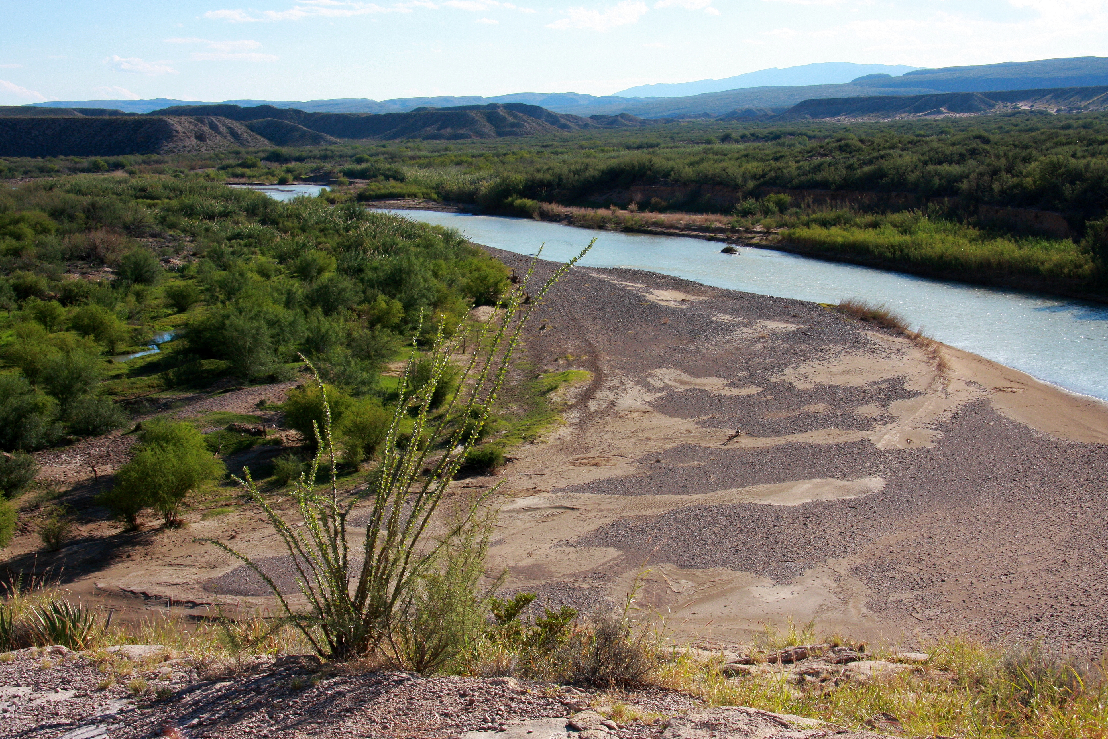
The Rio Grande, known as Río Bravo del Norte in Mexico and Tó Ba'áadi by the Navajo, is a colossal river system spanning 1,896 miles from its headwaters in south-central Colorado to its mouth at the Gulf of Mexico. This fourth-longest river in North America carves through arid and semi-arid territories, serving as a critical water lifeline for seven U.S. and Mexican states. Its fertile valley and tributaries sustain agriculture and communities across a vast watershed of 182,200 square miles, with adjacent endorheic basins expanding its effective drainage to 336,000 square miles. Despite its life-giving role, the river is a constant nexus of environmental, political, and social contention, particularly concerning water rights and border demarcation.
🎵 Origins & History
The Rio Grande's story begins in the San Juan Mountains of Colorado, where it emerges as a snowmelt-fed stream in the early stages of its 1,896-mile journey. Historically, Indigenous peoples like the Pueblo and Navajo have long understood and utilized its waters, with the Navajo naming it Tó Ba'áadi, meaning 'Water that Runs'. Spanish explorers, arriving in the 16th century, christened it Río del Norte, later evolving to Río Bravo del Norte as it became a significant geographical marker. For centuries, its course has been a dynamic force, shaping canyons and supporting life in otherwise desolate regions, predating and outlasting the establishment of modern borders and settlements.
⚙️ How It Works
The Rio Grande functions as a complex hydrological system, its flow heavily influenced by snowpack in the Rocky Mountains and, increasingly, by extensive irrigation and dam infrastructure. Major dams like Elephant Butte Dam in New Mexico and the Amistad Dam on the Texas-Mexico border regulate its flow, primarily for agricultural and municipal water supply. Tributaries such as the Pecos River and the Conchos River contribute significantly to its volume, though their flows are also managed. The river's gradient varies dramatically, from steep mountain descents to wide, slow-moving plains, impacting its sediment transport and ecological characteristics.
📊 Key Facts & Numbers
Stretching 1,896 miles, the Rio Grande ranks as the fourth-longest river in North America. Its drainage basin covers an impressive 182,200 square miles, a figure that swells to 336,000 square miles when considering adjacent endorheic basins. The river's average discharge is approximately 2,430 cubic feet per second, though this can fluctuate wildly based on seasonal precipitation and water management. Over 7 million people in the United States and Mexico rely on its waters for drinking, agriculture, and industry, with irrigation accounting for roughly 75% of its total water use. The river forms a significant portion of the international border between the U.S. and Mexico, spanning over 1,250 miles of this boundary.
👥 Key People & Organizations
Key figures associated with the Rio Grande include early explorers like Álvar Núñez Cabeza de Vaca, who traversed its upper reaches in the 1530s, and Juan de Oñate, who established Spanish settlements along its banks in 1598. More recently, figures like Franklin D. Roosevelt were instrumental in authorizing large-scale water projects under the New Deal that reshaped the river's management. Organizations such as the International Boundary and Water Commission (IBWC), established in 1889, play a crucial role in managing the river's shared resources and resolving border disputes between the United States and Mexico. The Rio Grande Valley International Museum also serves as a cultural repository for the region.
🌍 Cultural Impact & Influence
The Rio Grande has profoundly shaped the cultures and economies of the Southwest. Its fertile floodplains have supported agriculture for millennia, from ancient Pueblo irrigation systems to modern vast commercial farms growing cotton, pecans, and citrus. The river's presence is deeply woven into the folklore and identity of border communities, influencing music, art, and literature. It has also served as a historical pathway for migration and trade, connecting diverse peoples and cultures. The iconic imagery of the Rio Grande, often depicted as a majestic yet sometimes meager ribbon of water, has become synonymous with the American West and the complexities of the U.S.-Mexico border.
⚡ Current State & Latest Developments
In 2024, the Rio Grande faces persistent challenges related to water scarcity, exacerbated by prolonged drought conditions and increasing demand from a growing population and agricultural sector. The river's flow has diminished significantly in recent decades, leading to critical water shortages in regions like the Rio Grande Valley. Efforts are underway to improve water management efficiency, explore desalination technologies, and implement conservation strategies. The International Boundary and Water Commission continues to mediate water allocation disputes between the U.S. and Mexico, with ongoing negotiations regarding treaty obligations and drought contingency plans. The ecological health of the river, particularly its endangered fish species and riparian habitats, remains a pressing concern.
🤔 Controversies & Debates
The most significant controversy surrounding the Rio Grande is the allocation of its water resources. The 1944 Treaty between the United States and Mexico mandates specific water deliveries, but drought conditions have made fulfilling these obligations increasingly difficult, leading to frequent disputes. Another major debate centers on the river's role as an international border, raising issues of sovereignty, migration, and environmental impact from border infrastructure. Furthermore, the ecological consequences of reduced flows, increased salinity, and habitat degradation are subjects of intense scientific and environmental advocacy, with groups like The Nature Conservancy working on restoration projects.
🔮 Future Outlook & Predictions
The future of the Rio Grande is inextricably linked to climate change and regional water management policies. Projections indicate continued warming and altered precipitation patterns, likely leading to further reductions in river flow. This necessitates a paradigm shift towards more sustainable water use, including advanced irrigation techniques, water recycling, and potentially inter-basin water transfers, though the latter are politically fraught. The development of robust drought contingency plans and enhanced binational cooperation through the International Boundary and Water Commission will be crucial for navigating future water scarcity. Innovations in water conservation technology and a greater emphasis on ecosystem restoration will also define the river's trajectory.
💡 Practical Applications
The Rio Grande is a cornerstone of agriculture in the arid Southwest, supporting vast irrigation systems that produce billions of dollars in crops annually, including cotton, corn, and vegetables. It also provides essential drinking water for major cities like Albuquerque, El Paso, and Monterrey. The river's recreational potential is significant, offering opportunities for fishing, boating, and wildlife viewing, particularly in areas like Big Bend National Park. Furthermore, its role as a natural border has led to the development of border patrol and customs infrastructure, impacting regional economies and security.
Key Facts
- Category
- nature
- Type
- place